Glamorgan is split into two areas as far as bird reports are concerned. Together, the two recording areas constitute what is referred to as ‘Greater Glamorgan’.
East Glamorgan
The recording area covered by the East Glamorgan Bird Report comprises the geographical area of the Counties of Cardiff, Vale of Glamorgan, Bridgend, Rhondda Cynon Taf and Merthyr, together with the western part of Caerphilly (west of the River Rhymney). The island of Flat Holm and the inshore waters of the Bristol Channel adjacent to the coastlines of Cardiff, the Vale of Glamorgan and Bridgend are also included in the recording area, which was known by Glamorgan Bird Club as ‘Eastern Glamorgan’, however this has now been replaced by, simply, East Glamorgan, as being less ambiguous and tying in more logically with West Glamorgan. A map of the East Glamorgan recording area appears on the back cover of each printed Report. Records of birds in East Glamorgan should be sent to the Recorder, Phil Bristow, at phlbrstw@gmail.com.
West Glamorgan
Details of bird sightings in ‘West Glamorgan’ (comprising the geographical area of the Counties of Swansea and Neath Port Talbot), appear in ‘Gower Birds’, the annual publication of the Gower Ornithological Society. All records of bird sightings in ‘West Glamorgan’ should be sent to the Gower Recorder, Eddie Hunter, at goweros23@gmail.com.
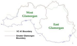
Readers should note, that due to a series of local government reorganisations within Wales, the border of Greater Glamorgan no longer coincides with that of the ancient county of Glamorganshire (Watsonian vice-county 41). This map shows that the border of Greater Glamorgan overlaps that of the adjacent vice counties, namely Carmarthenshire, Breconshire and Monmouthshire. In the east the recording area border north of Cardiff follows the river Rhymney.
Traditionally, bird recording has used the vice-county (VC) system in order to split the United Kingdom up into geographical areas. However, records from the Greater Glamorgan area are welcome.

You must be logged in to post a comment.